Table of Contents
Below are frequently asked questions about the Map settings.
Select the arrow to reveal the answers to your questions.
Map Settings
What do the symbols on the map mean?
Alerts
 |
Harsh Braking This alert triggers when a driver rapidly applies the brakes, resulting in a reduction in speed greater than 6.5 MPH per second. |
 |
High Speed This alert triggers when a vehicle travels faster than the High Speed Threshold you set on the Alert Settings page. The default value is 80 MPH. |
 |
Rapid Acceleration This alert triggers when a driver accelerates rapidly, resulting in an increase of speed greater than 8.5 MPH per second. |
 |
Speeding This alert triggers when a vehicle exceeds the threshold you set above the posted speed limit. |
Tracker Status
 |
Idling Displays when a vehicle has been idling for at least 3 minutes. |
 |
Moving Vehicle Denotes the direction in which a vehicle is moving. |
 |
Ignition Off (Stopped) Shows how long a vehicle has been stopped with ignition off. |
 |
Asset Assets have square icons, while vehicles have circles. |
 |
Asset Movement Without Ignition Asset tracker is moving but the ignition is off. |
 |
Asset Stopped
Asset tracker is not moving and ignition is off. |
 |
Mini Tracker Online Mini Tracker has received a signal recently. |
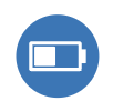 |
Mini Tracker Low Battery Mini Tracker has a battery level of 15% or less. |
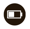 |
Low Battery Device is no longer reporting due to low vehicle battery. Please start car to resume reporting. |
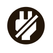 |
Unplugged
Device is no longer reporting due to being removed from power. Tracker may have been tampered with. |
 |
Power Off Mini Tracker is no longer communicating with our servers. Most likely the device is out of battery and needs to be charged. |
 |
No GPS Device is no longer updating its location because it does not have proper GPS signal. Please ensure vehicle is outside with clear view of sky. |
 |
Offline
Device is no longer communicating with our servers. Most likely out of cellular range. |
 |
Never Checked In Tracker has been activated but has not yet checked in. Please ensure that the tracker is installed and the vehicle has power and cellular signal. |
Why does my device appear on the map in red?
At times, your device will display a red icon on the map:
-
 A red pin marker indicates that your device has not tracked or reported in over three hours (49 hours for an asset) and may require your attention.
 -
 A red arrow marker indicates that an alert occurred at this location. The arrow indicates the vehicle’s location and the direction it was traveling.
 -
 A red circle marker indicates that an alert occurred at this location.
Here are some recommended steps to take if you believe the icon is showing red incorrectly:
- Red pin marker
- If your device has not been unplugged or unwired, it could be outside of a cellular service area. As long as the device still has power, all GPS coordinates will be saved and sent once service is re-established.
- Make sure your vehicle is in an open area and not in a parking structure. The tracking signal may be blocked in underground parking garages. The tracking signal may also be temporarily interrupted if your vehicle is in an area near a military facility or airport.
- Red arrow or red circle
- Clicking on either the red arrow or red circle markers will reveal the time of day that the alert occurred, the approximate address, the type of alert, and the direction and speed the vehicle was traveling if applicable.
If you would like more information on these alerts, simply click the ‘Alerts’ button at the top of the portal. On the Alerts List screen, select the day you would like to see, and choose a group, vehicle, alert type, and/or driver (or leave these options set to 'All'). Then click the ‘Show Activity’ button. In the list of alerts, you can click the Location link to see the GPS location where the alert occurred.
Why does the device appear on the map in grey?
It is normal for your device to display a grey icon on the map during the initialization process, but it can also turn grey when you are in an area of poor cellular or GPS coverage.
Take the following steps to identify and resolve the issue:
- Verify that the device has power by making sure lights are lit.
- If the device is powered, make sure that at least 60 minutes have passed since installation. The device requires up to 60 minutes following installation to obtain a cellular signal and GPS fix. See below to verify the correct light orientation:

- If the light orientation is correct, make sure your vehicle is in an open area and not in a parking structure. The tracking signal may be blocked in underground parking garages. The tracking signal may also be temporarily interrupted if your vehicle is in an area near a military facility or airport.
- If the device is a plug-in device, check to make sure the OBD port is functioning by testing it with an OBD scan tool, or by installing the device in the OBD port of another vehicle. If your device is a wired device, check installation by viewing our Wired Installation Video.
For further assistance, please contact Customer Support at support@motosafety.com or 877-732-4970.
Why is my map screen not loading?
There are a few reasons why the map screen may not load correctly:
- If you are using Internet Explorer, it must be Version 7 or above. Please upgrade.
- If you have McAfee or any other type of anti-virus plug-in on your browser, you must disable it and reload the page.
- Try clearing your browsing history and then reload the page.
How do I update posted speed limits?
The system determines speed limits based on information from Google Maps. However, you can update speed limits on frequently traveled roads if the information from Google Maps is currently not accurate:
- Click ‘Update Speed Limit’ in the top right corner of the map.
- Click ‘Update a Speed Limit’ in the pop-up window to create a new speed limit segment.
- Click two points on the map to select a road segment.
- Enter the updated speed limit for this road segment and click ‘Save.’
- To edit an existing segment, click the edit (pencil) icon next to the segment and enter a new speed limit.
NOTE: To reflect updated posted speed limits, ensure to update the speed limit both ways on the road.

How do I change my time zone?
To change your time zone:
- Select ‘Setup’ from the top toolbar.
- Select ‘Alert Settings’ from the left menu.
- In ‘General Settings’ section, locate the Time Zone and select your time zone from the dropdown menu.
- Select ‘SAVE CHANGES’ to apply your changes.

NOTE: To change your time zone to automatically align with daylight savings time changes, select “daylight” time.
Example: CDT.
What is clustering?
Clustering is a feature that enables you to collapse the number of individual tracker icons you see on the map. It is particularly helpful if you track a large number of vehicles or assets.
- Click 'Enable Clustering' at the top right side of the map. Tracker icons will be clustered into circles with a number, indicating the number of trackers in that location.
- Click ‘Disable Clustering’ to return to the default view of individual trackers.
What does the Reset Map button do?
The reset map button changes your map view so that no user histories or geofences are displayed and all users are visible.
This will NOT delete your users, user history data, geofences or saved map views, nor will it reset the map type you have chosen.
How do I find the vehicle closest to a certain address?
To find the vehicle closest to a certain location or address:
- Enter the address in the search bar at the top left corner of the screen and hit Return.
- Choose the address from the pop-up window that opens.
- A window will open marking the location on the map and displaying all vehicles with distance and estimated arrival time.
How do I change from miles to kilometers?
To change your distance units from miles to km:
- Navigate to the Map page.
- Select ‘Map Options’ from the top toolbar.
- Select kilometers from the Distance Units section. This will update automatically.

Device Settings
How do I change the name of my device?
Changing the name of the device is a simple process:
- Click ‘Setup’ at the top of the screen.
- Under ‘Tracker Setup,’ click the first name or last name you wish to change. An editable field will appear.
- Type in the new name and click outside the edit field to save.
- You can also click the Edit icon for each vehicle to update the name, as well as the group and VIN.
How do I update the odometer?
To update your odometer:
- Select your device from the ‘Map’ or ‘Setup' page.
- Select the edit pencil.
- Enter the new odometer.
- Click ‘Save.’
How is the year, make, and model added to the device?
The device may read the Vehicle Information Number (VIN), which can be used to decode the year, make, and model, and show this information on the portal.
If the device does not automatically transfer the VIN to the portal, you can manually add the VIN to your device on the Setup page to populate the vehicle year, make, and model.
How do I add or update the VIN?
To add or update your VIN number:
- Select your device from the ‘Setup' page.
- Select the edit pencil.
- Enter the VIN.
- Click ‘Save.’
Return to Map